Thursday, Nov 21 through Thursday, Nov 28 -- Thankful to get to Thanksgiving!!
Thursday-Friday, Nov 21-22 -- Our enjoyable time in Charleston having come to an end, it was time to get ready to head for St Marys, GA, where we planned to join other cruisers for a communal Thanksgiving. Here is Fred ironing his jeans in preparation for the trip:
 |
| Fred ironing his jeans |
Just kidding! If you look closely you can see that Fred is ironing patches onto both knees of his jeans, which Dorothy then reinforced with stitching (sewing machine is on the dinette seat forward of the table). Our inverter is 300 watts, whereas Dorothy's little travel iron (which was her mother's!) is 650 watts -- so we need shore power to use the iron. Although the sewing machine works fine on the inverter, the iron's high wattage requirement means that patching and quilting are pretty much dock restricted to when we are at a dock with shore power -- unless we opt for a higher-powered inverter at some point, but we'll see on that ... patching and quilting are only occasional activities, and so far, doing them when we have shore power has really been ok.
While in Charleston, Dorothy made some additional headway on Ian's graduation quilt (OK, he graduated in 2012 ... I'm working on it!!):
 |
| Ian's Middlebury College graduation quilt top in progress! |
We were leaving Charleston on Thursday, Nov 21, and wanted to arrive in St Marys, GA, no later than end of day Tuesday, Nov 26, so that we could enjoy the town and make our Thanksgiving dish to share on Wednesday, Nov 27. That gave us 6 sailing days to cover about 170 nautical miles -- about 30 nm per day. That is quite doable if conditions are favorable, but weather is always a consideration, and since we had some heavy weather in the forecast, we were eager to get some miles under our belt.
We set out from Charleston around 9:30 am, headed at least for the North Edisto River, and beyond if possible. The wind was brisk, NE 16-20 knots, so we just put out about 1/2 of the jib. The waves were 4-6 feet, but the wind eased down to 13 knots mid-afternoon,on our stern quarter, resulting in the dreaded slatting (big wave -- boat tips one way-- jib loses air -- boat tips back -- jib refills and slams back over -- repeat -- repeat -- repeat ... not good for the rig and not exactly pleasant sailing), so we put out the whisker pole. Then the wind picked back up to 20-22 knots, the waves increased to 4-8', and while we had a bit of a wild ride with those big waves, we made good progress, 5.5 to 6.6 knots over ground, with 1/2 jib only. We decided to go for the gusto and continue overnight to Doboy Sound in Georgia!
 |
| Sea state and sky as sun is getting low |
Fred took the first watch (shift), 6 to 9 pm, and Dorothy tried to sleep ... uneventful. Dorothy took the next watch, 9 to 1 -- and things got busy! The wind lightened -- engine on. Rain. The wind strengthened -- engine off. The call of a loon close to the boat. And then ships!! Near Savannah, 9:30 pm, Dorothy was at one point tracking the distance and bearing of six ships. The radar comes in very handy for monitoring ships at night, particularly in heavy seas, as it is very hard to tell if the bearing of a "target" is constant when the boat is yawing / rolling. Meantime, it was Fred's turn to sleep, or try to, as Aviva continued to rock and roll in the waves. The dinette was a bit less rolly than the forward cabin.
 |
| Sleeping (or at least trying) Beauty! |
The moon came out, surrounded by haze:
 |
| Hazy moon |
 |
| Moon bisected by the mast |
Then Fred took over again, until 4 am or so ... no more ships, and wind and waves began to subside, giving Dorothy a better sleep!
Then Dorothy was on again for the dawn hours, heading for the MoA (flashing pattern Morse Alpha) buoy marking the inlet for Doboy Sound. When Fred got back up, we removed the whisker pole, rolled out the jib all the way ... wind died ... slatting ... engine on ... course change to avoid a fishing trawler... roll up jib ... buoys missing in sound ... and by 11:30 am we were anchored in the Dulpin River and ready for a rest.
 |
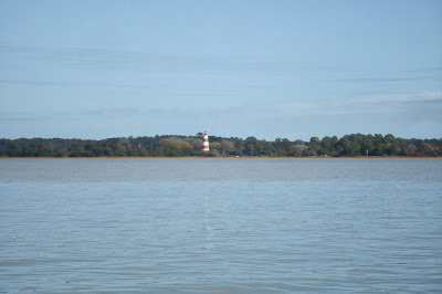
| Doboy Sound light house |
Our anchorage in the Dulpin River was just beautiful:
 |
| Dulpin River anchorage |
Late afternoon, it happened to be low tide, so Dorothy took the dinghy upriver to do some birding on the mud flats. The water was so calm that driving the dinghy was like planing on glass. Dorothy is no expert on peeps but thinks she saw dowitchers (don't know what kind!), great blue heron, dunlins, semi-palmated plover, and a snowy egret or little blue heron. As the sun set, the peeps dispersed and the no-see-ums came out ... time to head back to the boat for dinner, with this beautiful view:
 |
| Sunset over the Dulpin River, Georgia |
Saturday, Nov 23 -- A lighter wind day, the calm before the storm, with winds clocking around. On the passage from Charleston to Dulpin River (above), our wind was
NE from Thursday morning on through that day and overnight. It shifted to
ENE at about 5 am Friday, then
E by 6:30 am, beginning the clocking around cycle. This morning, Saturday, it had clocked around further, and we started the day
SW 5 kts, ended
WNW 6. Dear Reader, can you guess what direction is coming next as it clocks the rest of the way around? Exactly!! It means you're going to want protection from the north ... it's going to blow! How did I live 58 years and never know that? Anyway, I digress and am getting ahead of myself.
As we left the Dulpin River, per the cruising guide we were headed to a shallow area of the ICW. True to expectations, we heard radio calls of boats aground and boats reporting areas where the water was "thin." Fortuitously, as we left our anchorage around 9 am, the tide was rising, with high tide due about noon. A mid-rising tide is ideal when you are traversing shallow waters, in that if you do run aground, the water will continue to rise, and hopefully you can get off. With a falling tide, you could be stuck quite a while. Anyway, I digress again!
As we left the Dulpin River, headed back into Doboy Sound, we saw this ferry of folks ...
 |
| Ferry in Doboy Sound, GA |
It was a quiet day, motoring. We passed through the Altamaha State Waterfowl Management Area, graced with a fly-by by two great egrets, crossed Altamaha Sound to Buttermilk Sound, then split off to the Frederica River, the ICW alternate route that offered good depth and that sounded both pretty and protected. Not to mention the name! Some Frederica River sights:
 |
| Grasses along the Frederica River |
 |
| Boat dock and storage along the Frederica River |
 |
| Spanish Moss in trees along Frederica River |
 |
| Lone palm, Frederica River |
 |
| Fort -you got it -- Frederica |
 |
| Sailboat on Frederica River -- named -- you got it -- Frederica |
After 5 hours of motoring, we were anchored in middle of the Frederica River, just above Manhead Sound, which leads into Saint Simons Sound. In 22 feet of water (high tide), we put out 180' of chain and hunkered down under a big rain cloud, ready for the pending cold front with gale force winds expected.
Sunday, November 25 -- We didn't move, and this is our only picture from the day:
 |
| Wind! |
We didn't get a picture of the maximum wind! We didn't want to go out there!
There is always the question, when anchored in a river, of whether the boat is going to swing back and forth with the tidal current. In the Cohansey River, in Delaware Bay, where a strong cold front came through, the tidal current was strong enough that it won out over the wind, and the boat swung with the current. Here, on the Frederica, the wind won out over the current, and the boat pointed north throughout the passage of the front. Who cares? Well ... when you swing, you will be located the entire length of whatever scope you have out in the opposite direction from where you were originally. For example, with 180 feet of chain out, if you swing 180 degrees with the current, you will be 360 feet from where you were lying originally. Two considerations around that are -- (1) what's the depth there, and (2) will the anchor hold or re-set when pulled from the opposite direction? So far, except for once on Back Creek in Annapolis when we dragged, our anchor has held. Knock on wood!
Monday, November 26 -- Two travel days left to reach St. Marys by our goal of end-of-day Tuesday, with 36 to 39 nautical miles to go, depending on whether we go inside (in the ICW) or outside (pop out into the Atlantic at St Simons Sound, then back in at St Marys - Fernandina inlet). Either way, that is a feasible distance to cover in one day. Decisions, decisions! Motoring in the ICW has consistently been prettier than expected, but still, the operative word is motoring, and we'd just as soon sail where possible. Today Dorothy was "captain of the day," and she opted to try the outside route, subject to how it looked once we got out there, as it was still blowing pretty strongly from the cold front (NNE 16-20 knots as we set out at 8:30 am).
First thing, we went under the FJ Torras Causeway. Nothing extraordinary here, just thought it might be of interest, as most of you readers are probably more used to going
over bridges. This bridge has 65' vertical clearance, and looks the way most bridges look on approach:
 |
| FJ Torras Bridge next to St Simons Island, GA |
Below is how it looks to us as we pass under. Doesn't it make you want to duck??? We had about 10-11 feet of clearance, but even looking at this picture I want to duck!!
 |
| Aviva's mast - passing under FJ Torras Bridge |
From here, we headed through St Simons Sound out toward the open sea. It started to drizzle, and with the wind and waves we were seeing, and the temperature being 50 degrees, Dorothy decided to put on her full foul weather gear (aka "foulies"). Good call!! As we rounded Neptune Park and got further out into the sound, the wind picked up to 18-22, gusting near 30, with waves increasing in size -- we were getting hammered. Dorothy's turn-around point was gusts over 30, the thought being that if it was gusting over 30 in the sound, it was likely to be even worse further out there. As much as we want to get experience in all conditions, we don't intend to knowingly sail into a gale (35 knots). And cruisers frequently remind each other that there is no shame in poking your nose out and turning around if it doesn't look good.
When the gusts hit 31 knots, Dorothy turned the boat around and we headed back in to the ICW. Now the ICW in this area still goes through the sounds. So it wasn't like the wild ride was over. Indeed, as we plowed our way through St Andrew Sound, more than 2 hours after leaving, it was blowing NNE 28 and gusting to 34.
These were the toughest conditions we had encountered, and it was rough. It took most of Dorothy's strength to steer the boat through St Andrew Sound and was exhausting. But we did it! And Hallelujah, when we got into Cumberland Sound, the wind dropped to 22 (!) and we were able to put out the jib, cut the engine, and sail on a dead run all the way to the St. Marys River.
By around 2 pm, the wind had dropped to 13 knots ... what a relief! At Kings Bay in Cumberland Sound, we passed the
Kings Bay Naval Submarine Base,
home port to the US Navy Atlantic Fleet's Trident nuclear-powered submarines. A large escort ship radioed to tell us they were just about to leave, and to leave them plenty of room. We did! (But they didn't leave until we were almost turning into the St Marys River). Here are a few (unclassified) photos we took as we passed the facility:
 |
| Kings Bay Naval Submarine Base structure |
 |
| Kings Bay Naval Submarine Base buildings |
 |
| Kings Bay Naval Submarine Base submarine escort ships |
At about 2:45 pm, we turned into the St Marys River, and by 3:30 pm we were anchored!! Below is Dorothy, still suited up, very happy to have made it!
 |
| Awesome day! |
Tuesday, November 26 -- Touring St Marys!
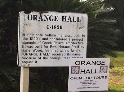
St Marys is one of the oldest towns in the south, chartered in 1787. It has a variety of small shops and a beautiful park on the waterfront. There is a full-service marina, and plenty of room for lots of boats to anchor. Here are a few shots of historic buildings:
 |
| Orange Hall, c. 1829 |

 |
| First Presbyterian Church |
Wednesday, November 27 -- Since it had been over 24 hours since we'd had heavy wind, apparently it was time for some more! Accordingly ...
 |
| Someone took the extra big mooring ... way to be safe in a blow! |
 |
| Our transom flag patriotically standing at attention |
 |
| More wind! |
You can't really tell it in this photo, but the river and all the boats in the anchorage were rocking:
 |
| Windy river, water sloshing, boats rocking |
Thanksgiving -- Thursday, November 28 -- Turkey Day!
With our two freshly-baked pecan pies in hand, we headed into shore around noon -- time for the big feast!
Thanksgiving is generously hosted by Gayla and Jerry Brandon, at their Riverview Hotel and Seagles Restaurant and Saloon, and other town residents. It is a big potluck, and I do mean big!!
 |
| Site of Thanksgiving festivities (love the Hippies sign!) |
 |
| Feasters assembling, lining up outdoors |
 |
| Yum |
 |
| Yum |
Ann Barr and her husband Lynn Harden have attended for years and are the cruiser organizers.
 |
| Local cruiser contact and organizers Ann Barr and Lynn Harden |

Others pitch in with the organizing as well, like Jage North, Pete and Stephanie Peterson.
 |
| Jage North |
 |
| Feasters feasting |
 |
| Annapolis Boat Show workers who attended Thanksgiving, plus a few more folks |
 |
| Feasters feasting |
It was a HUGE spread of WONDERFULLY TASTY DELIGHTS, turkey with all the trimmings, ham, sides, and there was plenty of food!! And the next day, we got together again for a pancake breakfast and swap-meet. (Certain syrup-snobby Vermonters brought their own maple syrup!)
Dorothy gave some of the organizers tissue pack covers, and Stephanie Peterson was so excited about them as stocking stuffers that she bought four more. That was a nice surprise ... and covered breakfast!
Friday, November 29 -- Time to go!
Thanksgiving was wonderful, but we could not help noticing that the temperatures were still
COLD! Knowing that warmer climates awaited, we were ready to move south -- seriously!!
First a quick repair -- we had noticed that a folded-under flap on the UV cover of our new jib had come unfolded and was flapping wildly in the recent heavy winds. Today, with moderate breeze and some blue sky, was perfect for the job:
 |
| Dorothy up the jib in the bosun's chair |
 |
| Dorothy will sew anything, anywhere! |
We didn't quite hit the 1500 nautical mile mark, but we are so close, I can't help but include this -- 1400+ miles traveled!!
Next post - - Passage to Florida...stay tuned...


